

Searching for Larches in the Canadian Rockies!
For the past four years, we’ve made it a tradition to visit the Canadian Rockies every fall to celebrate our birthdays and witness the stunning larch trees! These unique coniferous trees shed their needles each autumn, turning from vibrant green to a brilliant golden yellow before they fall.
In the Canadian Rockies, you can find larches in Banff, Yoho, Kootenay, and Waterton Lakes National Parks, as well as in Kananaskis Country and the West Kootenays. There are four species of larch in North America, all of which turn golden in the fall. In these regions, the primary species is the subalpine larch (Larix lyallii), typically found above 1800 meters in elevation.

Insider Tip: Larch season in the Canadian Rockies can be unpredictable and short-lived. Usually, the needles start to turn yellow in mid to late September and last until early October. Over the past three years, we’ve noticed the timing shift slightly each year, so it’s best to keep your plans flexible and be ready to adjust your hikes accordingly.
This guide highlights some of our favourite larch hikes, along with recommendations on where to stay and what to pack!


Kootenay National Park:
Kootenay National Park is a stunning natural sanctuary that showcases a diverse range of landscapes, from rugged mountains and glaciers to hot springs and deep canyons. Visitors can explore an array of outdoor activities, including hiking, wildlife viewing, and soaking in the Radium Hot Springs. The park is also home to rich forests, crystal-clear rivers, and unique geological features like the Painted Pots, making it a must-visit destination for nature lovers and adventure seekers.
Fee information: Kootenay National Park charges a fee to enter. For more information, please visit the Parks Canada website here.
Kootenay Trails:
Diana Lake:
Diana Lake is an enchanting uphill hike leading to a tea house. The trail takes you through diverse terrain, including forests, meadows, stream beds, and mountain lakes.


Distance: 13.2km roundtrip
Elevation Gain: 729m
Type: Out & back
Difficulty: Hard
Location: East Kootenay
Access: Gravel Road - 2WD
Insider Tips: We suggest walking around the lake and starting the climb to the Judge for a stunning view of the lake looking back down the valley. The tea house has seasonal closures near the end of September, so always check the Diana Lake website for updated information.
Stanley Glacier:
This trail starts with a creek crossing before steadily gaining elevation on long switchbacks through a new-growth forest. The section near the Lower Falls can be wet and muddy, so water-resistant footwear is advisable. Hiking poles are also beneficial due to the boulders and loose scree along the route. Larches at the top are minimal but make for beautiful photo ops with the glacier in the background.


Distance: 10.9km roundtrip
Elevation Gain: 607m
Type: Out & back
Difficulty: Hard
Location: Kootenay National Park
Access: Paved Road - 2WD
Insider Tip: This trail is one of the most popular in Kootenay Park, so arriving early is recommended to secure a parking spot.
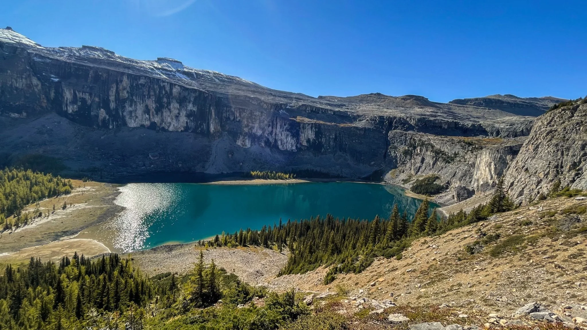
Floe Lake:
The trail to Floe Lake begins with a flat stretch and two bridged river crossings before ascending through forested switchbacks. Don’t be deceived by the flat section after the treeline—the final ascent is the most strenuous, with steep switchbacks that seem never-ending. However, the breathtaking view of Floe Lake, nestled against dramatic granite cliffs, makes the effort worthwhile.


Distance: 20.3km roundtrip
Elevation Gain: 976m
Type: Out & back
Difficulty: Hard
Location: Kootenay National Park
Access: Paved Road - 2WD
Note: if you’re planning to camp overnight, be sure to reserve your campsite well in advance.


Where to Stay:
Kananaskis Country:
Kananaskis Country, located in the foothills and front ranges of the Canadian Rockies in Alberta, is a vast and picturesque region known for its rugged beauty and outdoor adventure opportunities. Spanning over 4,000 square kilometers, it includes several provincial parks, wildland areas, and recreation zones.
Visitors can enjoy activities like hiking, mountain biking, skiing, and wildlife viewing amid breathtaking landscapes of towering peaks, alpine meadows, and pristine lakes. Kananaskis is also home to the renowned Kananaskis Nordic Spa and offers a more tranquil, less crowded alternative to the nearby national parks, making it a favorite for both locals and tourists seeking a serene wilderness experience.
Fee Information: A Conservation Pass is required to park at Provincial Parks and public use lands in Kananaskis Country and Bow Valley. For more information on purchasing a pass, visit the Kananaskis Conservation Pass website.
Kananaskis Trails:
Chester Lake:
This trail begins with a steady climb through the forest along gentle switchbacks. About 2.6 km in, the trail levels out, revealing a wide clearing with stunning mountain views and a beautiful meadow.
After briefly re-entering the forest, the trail opens up again, leading to the iconic Chester Lake. The trail continues around the lake, becoming narrow, rocky, and root-filled as it heads toward Elephant Rocks before turning back.

Distance: 9.3km roundtrip
Elevation Gain: 419m
Type: Out & back
Difficulty: Moderate
Location: Peter Lougheed Provincial Park
Access: Gravel Road - 2WD
Note: Bicycles are only permitted along the first 2 km of the trail. The rocks can become snow-covered and slippery, so proper footwear is recommended in the fall.
Tent Ridge:
Tent Ridge is one of Alberta’s most popular larch hikes—and for good reason! We recommend starting before sunrise to secure a parking spot and avoid crowds, especially on weekends.

This moderately challenging hike is best tackled clockwise if you’re completing the entire loop. If you only plan to hike to the ridge or the valley below, go counter-clockwise to avoid the scramble sections.
Although the scramble to Tent Ridge summit is beginner to intermediate level, the trail involves significant elevation gain. Given the rocky terrain, it’s best to leave animals and small children at home although we have completed the trail twice with Aspen in the backpack carrier.
Distance: 10.1km roundtrip
Elevation Gain: 810m
Type: Loop
Difficulty: Hard
Location: Spray Valley Provincial Park
Access: Gravel Road - 2WD
Where to Stay:

View from the hot tub at Basecamp Resorts Canmore at sunset
Banff National Park:
Banff National Park, established in 1885, is Canada's oldest national park and one of the world's most iconic wilderness destinations. Located in the heart of the Canadian Rockies in Alberta, Banff is renowned for its stunning landscapes, including turquoise glacial lakes like Lake Louise and Moraine Lake, towering mountain peaks, and vast forests. The park offers a wealth of outdoor activities year-round, from hiking and wildlife viewing to skiing and snowboarding in the winter. Visitors can also explore the charming town of Banff, which provides a mix of luxury accommodations, fine dining, and cultural experiences, all set against a backdrop of unparalleled natural beauty.
Banff Trails:
Rockbound Lake:
This hike begins with a steady climb through a mixed forest, leading behind the dramatic cliffs of Castle Mountain to Tower Lake, 7.5 km from the trailhead. The trail then ascends a low cliff band, emerging in a glacial cirque filled with the stunning Rockbound Lake. We recommend wrapping around the east side of the lake and climbing the ridge for a bird’s-eye view.
Rockbound Lake from the Eastern hillside
Distance: 18km roundtrip
Elevation Gain: 934m
Type: Out & back
Difficulty: Hard
Location: Banff National Park
Access: Paved Road - 2WD
Note: Parking at this trailhead is limited and fills up quickly. Have a backup hike in mind, and remember that roadside parking is not allowed. Real-time parking lot info: parks.canada.ca/banffnow
Alternative parking can be found opposite the Castle Mountain Gas Station. It is then a short walk over to the trailhead.
Little Beehive & Lake Agnes Tea House:
The trail to Little Beehive gradually climbs the edge of Lake Louise. The well-maintained path offers steady inclines and several great vistas, including Mirror Lake and Lake Agnes. At Lake Agnes, you can visit the teahouse for tea and cake by a waterfall.

Distance: 9.2km roundtrip
Elevation Gain: 586m
Type: Out & back
Difficulty: Hard
Location: Banff National Park
Access: Paved Road - 2WD
Insider tips: The teahouse has seasonal closures starting in October, so check with Parks Canada for the latest information.
This trail is exposed to avalanche hazards in the winter, so it’s not recommended between mid-October and mid-June. If you still choose to hike during this time, bring microspikes..
Parking is available by the resort on Lake Louise. The lot is large but can fill up quickly so getting there early or booking a shuttle is recommended.

Sentinel Pass:
Often considered the crown jewel of larch hikes in the Canadian Rockies, the Sentinel Pass via Larch Valley Trail is a breathtaking but challenging hike. Start by following the flat lakeshore path, then branch off to the right, climbing 2.4 km along steep switchbacks through a stunning forest. Once past the junction, the trail gradually climbs through a larch forest and then opens up to offer panoramic views of the surrounding peaks.


Distance: 11.1km roundtrip
Elevation Gain: 749m
Type: Out & back
Difficulty: Hard
Location: Banff National Park
Access: Shuttle or private bus
Note: Moraine Lake Road and parking are closed to personal vehicles. To reach the trailhead the park provides a shuttle service from Banff or Lake Louise which must be booked in advance. Alternatively, you can reach the trailhead by cycling or walking. Follow this link for more information or to reserve your shuttle.
Things to Do:
Lunch at the Fairmont Chateau Lake Louise
Moraine Lake Shuttle
Banff Gondola
Drive the Icefields Parkway
Where to Stay:
Bonus: 10 Alternate Larch Hikes in the Canadian Rockies:
Arnica Lake Trail (Banff National Park) 9.3 km rt
Burstall Pass (Kananaskis) 16.4km rt
Fairview Mountain (Lake Louise, Banff National Park) 10.6km rt
Headwall Lakes (Kananaskis) 15.9km rt
Healey Pass and Sunshine Meadows (Banff National Park) 18.3km rt to Healy Pass, 21.1km rt to Sunshine Meadows
Lake O’Hara - Opabin Plateau Route (Yoho National Park) 8.5 km rt
Little Arethusa and Arethusa Cirque (Kananaskis) 4.8km rt
Pocaterra Ridge (Kananaskis) 9.8km rt
Rawson Lake (Kananaskis) 8.9km rt
Taylor and O’Brien Lakes (Banff National Park) 14km rt
Gear:
I’ve put together a Day Hiking Checklist with a complete list of gear recommendations.
And as always, here’s a few reminders for recreating responsibly from the Parks Canada team and Leave No Trace Canada:
Rules for exploring our beautiful backyard:
Plan and prepare:
Plan your travel route
Get your Parks Canada pass
Know the terrain and conditions - you can find detailed information about trail conditions, warnings and closures, fire updates and wildlife on the Parks Canada Website
Check the weather
Fill out a trip plan (check out AdventureSmart for more information)
Be considerate of wildlife and other visitors:
On narrow trails, give way to uphill hikers.
Take breaks on durable surfaces off the trail.
Give freedom for the sounds of nature. Avoid excessive noise.
Pack out what you pack in, and help clean up the trails on your adventures.
Keep dogs on a leash at all times, and properly dispose of their waste.
Permits are required for fishing and watercraft.
Feeding wildlife is illegal.
Drones are prohibited in all Canadian national parks.
Always carry bear spray and know how to use it.
And most importantly, have fun!
Parks Website(s):
Disclaimer: This blog post may feature some affiliate links, which means I get a small commission if you make a purchase (at no extra cost to you). It’s one of the ways I can keep producing free guides and resources for my readers. Thank you for the support!