Backpacking Flora Lake Loop, Chilliwack BC
The Flora Lake Loop, including Lindeman and Greendrop Lakes, is a popular hiking trail located in Chilliwack, British Columbia, Canada. This scenic route is part of the Chilliwack Lake Provincial Park and offers stunning views of the surrounding mountains, forests, and alpine lakes.
Indigenous History
The area around Chilliwack Lake and its surrounding trails, including the Flora Lake Loop, is part of the traditional territory of the Stó:l ō First Nations. The Stó:l ō people have lived in the region for thousands of years, utilizing the land and waterways for fishing, hunting, and gathering. The lakes and trails would have been part of their seasonal movements and resource-gathering activities.
Development of the Flora Lake Loop
The Flora Lake Loop is a challenging hike that connects several lakes in the area, including Lindeman, Greendrop, and Flora Lakes. The trail was developed over time by outdoor enthusiasts and maintained by local hiking clubs and park authorities. The loop is known for its diverse terrain, ranging from dense forests to alpine meadows and rocky ridges.

Lindeman Lake
Lindeman and Greendrop Lakes
Lindeman Lake is one of the most accessible and popular destinations in the area. It was named after a local settler and is known for its striking turquoise waters, which are a result of glacial silt. Greendrop Lake, located further along the trail, is another beautiful alpine lake surrounded by rugged peaks and dense forests. Both lakes are popular spots for camping, fishing, and photography.

Basking in the sun at Greendrop Lake
Backpacking the Flora Lake Loop
Some trails just stick with you—the kind that test your endurance, reward you with jaw-dropping views, and make you appreciate every warm sip of coffee in the morning. Flora Lake is one of those. Nestled deep in the Chilliwack River Valley, this loop is a stunning yet challenging overnight hike, (especially if you tackle it early season like we did). With lingering snow, tricky creek crossings, and some serious boulder fields, it was a wild ride—but absolutely worth it.
Trail Stats & Route Overview
Total Distance: ~20 km loop
Elevation Gain: ~1,400 m
Trailhead: Post Creek Parking Lot, Chilliwack Lake Road
Route: Lindeman Lake → Greendrop Lake (out & back) → Flora Lake → Flora Ridge & Peak → Down to trailhead
Best Season: July–September

Flora Lake Tent Pad
Lindeman & Greendrop Lakes: The Approach
The hike starts at Post Creek Trailhead, following a well-used trail to Lindeman Lake (1.5 km, ~200 m gain). This section is short but steep, with roots and rocks to navigate. Lindeman’s emerald-green water is a common day-hike destination, so expect to see other hikers here.
From Lindeman, the trail continues another 5 km to Greendrop Lake, gaining ~350 m in elevation. This section is more technical, with a mix of forested trail and rocky terrain. The boulder fields begin here, requiring careful foot placement, especially with overnight packs.
The last bit of the trail to Greendrop is an out and back section so we took off our packs at the junction and headed out to the lake for a quick break before pushing on. Beyond this point, the trail sees much less traffic.

The far end of Lindeman Lake
Snowy Terrain & Flora Lake Camp
The stretch from Greendrop to Flora Lake (4.5 km, ~450 m gain) was by far the toughest part of the hike. It kicks off with a steady climb up to the pass before levelling out briefly in an open meadow—though in early season, it was more of a flowing creek, making dry feet impossible. After that, the trail dives back into the boulder fields, which were still buried under snow. Navigating them was tricky, with every step a gamble between solid footing and sinking in up to an ankle.
By the time we reached Flora Lake, we were more than ready to set up camp. Most tent pads were still buried in snow, but we managed to find one that was clear. Getting a fire going in the damp, snowy conditions was frustrating, but eventually, we made it work.
Note: Fires are no longer permitted in this backcountry zone.


Typical boulder crossing en route to Flora Lake


Climbing to Flora Ridge & Peak
The next morning, we packed up early and began the steep climb to Flora Ridge (~500 m gain over 3 km). With the trail still buried under snow, navigation was slow and challenging. In some areas, the snow was deep enough to obscure the path entirely, making an offline map essential. Ours wasn’t cooperating, so I took the lead—only to promptly guide us in the wrong direction.
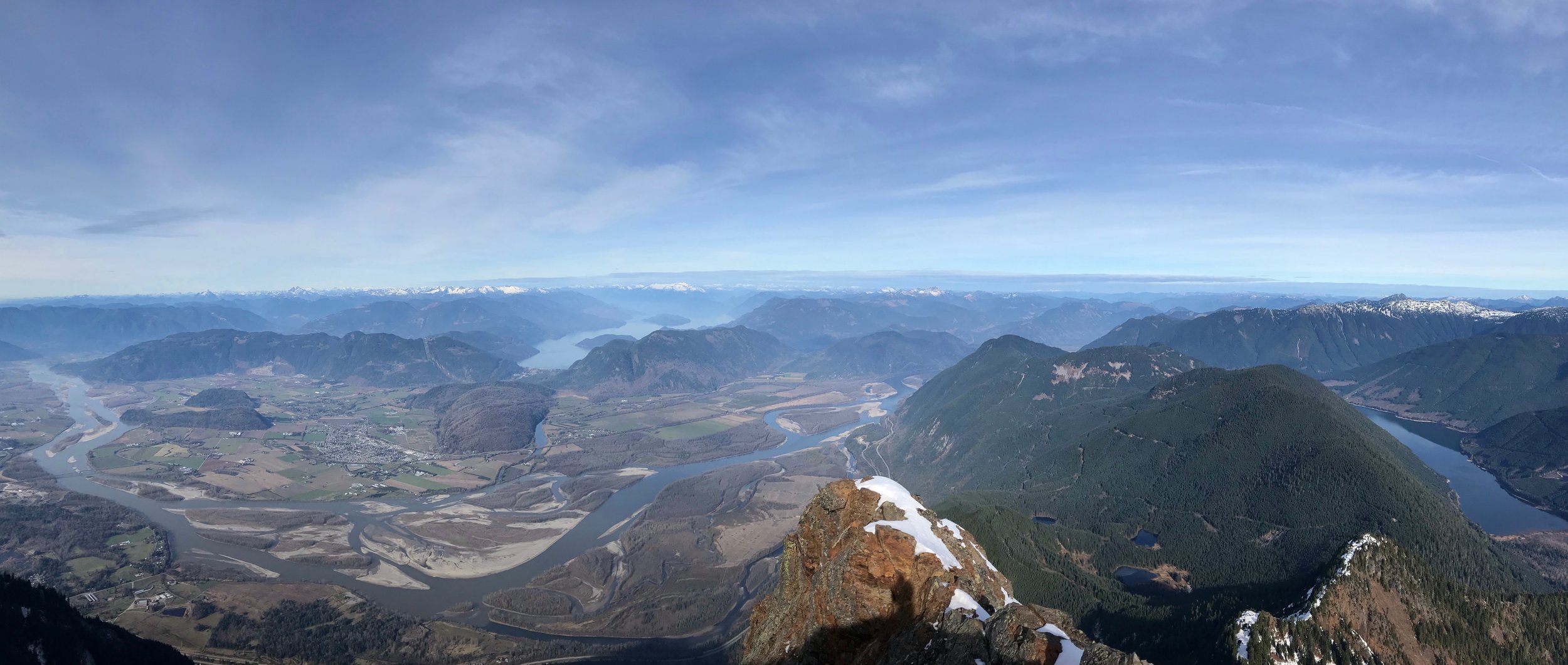
The creek crossings were also more challenging than expected, with high water levels requiring extra caution but once we reached the ridge, we were met with panoramic views of the Chilliwack River Valley. One of the best spots on the ridge is the heli-pad viewpoint, a wide-open section with stunning views. From here, we did a quick out-and-back to Flora Peak (~1 km, ~200 m extra gain) before starting the descent back to the car.
Descending with heavy packs on steep, sometimes snowy terrain was tough on the legs, but once we dropped below the snow line, the trail became much more manageable.


Views of Flora Lake from the ridge
Trip Planning & Logistics
Trailhead Access: The trailhead is located at the far end of Chilliwack Lake Road, just before Chilliwack Lake Campground. The road is paved and accessible to all vehicles. However, it’s advisable to be cautious, as there have been reports of vehicle break-ins in the area. Some hikers opt to park at Chilliwack Lake and hike the additional 1.5 kilometers to the trailhead for added security. We parked at the trailhead, without issue, however, we were sure to empty out our vehicle and left signs saying that there were no valuables left behind.
Permits and Reservations: Backcountry registration is required for all backcountry campgrounds within Chilliwack Lake Park. Included are Lindeman, Greendrop, Flora, and Radium Lakes. Get a backcountry camping permit or find out more about backcountry registration.
Camping fee: $5 per person per night (6+)
There is no cell phone reception past the On the Way store on Chilliwack Lake Road. Please make reservations prior to your trip.
Parking: Parking is available at the trailhead, but spaces can fill up quickly during peak season. As mentioned, consider parking at Chilliwack Lake and hiking to the trailhead if you’re concerned about vehicle security.
Gear and Supplies: Before embarking on your hike, ensure you have appropriate gear for the challenging terrain and variable weather conditions. Valhalla Pure Outfitters in Abbotsford offers a range of backpacking equipment for rent or purchase.
Water: Several water sources are available along the route, but a filter is necessary.
Fires are not permitted in the backcountry.
Trail Conditions: June snow can make navigation tricky. By July, most of it melts, making the hike more straightforward.
When visiting the backcountry, always follow Leave No Trace outdoor ethics. To learn more about staying safe in the backcountry, read BC Parks backcountry guide.
Flora Ridge
This loop is a solid challenge, even in ideal conditions. Early season added another layer of difficulty, with snow-covered boulders and high creek crossings making for slow travel. That said, the scenery—especially from Flora Ridge—made every tough section worthwhile.
If you’re planning this as an overnight, check out my backpacking checklist to make sure you’re prepared.
And if you’re hiking in June, be ready for snow—you’ll likely be dealing with it one way or another.

Flora Lake Campground

Flora Lake from the Ridge